More often than not, people want fences installed on property lines. Or at least very close to them. That is assuming you know where your property lines are located.
After 26 years in the fence industry, my experience is that most homeowners don’t really know where their property ends and the neighboring property begins. Especially in older, more mature yards.
On every fence quote I ran I would ask the homeowner if they knew where the property lines where located. When doing so, I received two common answers.
The firsts was, I think I know where they are. The second was, oh yes, my neighbor showed me where they are. As far as installing a fence is concerned, neither of those are satisfactory answers.
So in this article, we are going to look at the different types of maps used for establishing property lines and where to find them. We’ll also discuss fence layout and who is responsible for installing it correctly.
Property Line Maps
A property line map is a map that shows the outline of a lot, the dimensions of each property line and with any luck, where the house or building sits within the lot.
When it comes to establishing a fence line, having a map with this information is very helpful. Furthermore, when applying foe a fence permit, they are perfect for drawing the location of the proposed fence on.
There are many types of maps that will help you to identify the dimensions of your property. Some will provide the exact layout and dimensions. While others specifically state not to use for establishing boundaries.
Some types you probably already have. Others you can pull from the internet. However, the most accurate of all, a property line survey, will require an extra investment. Let’s review the different types of maps below.
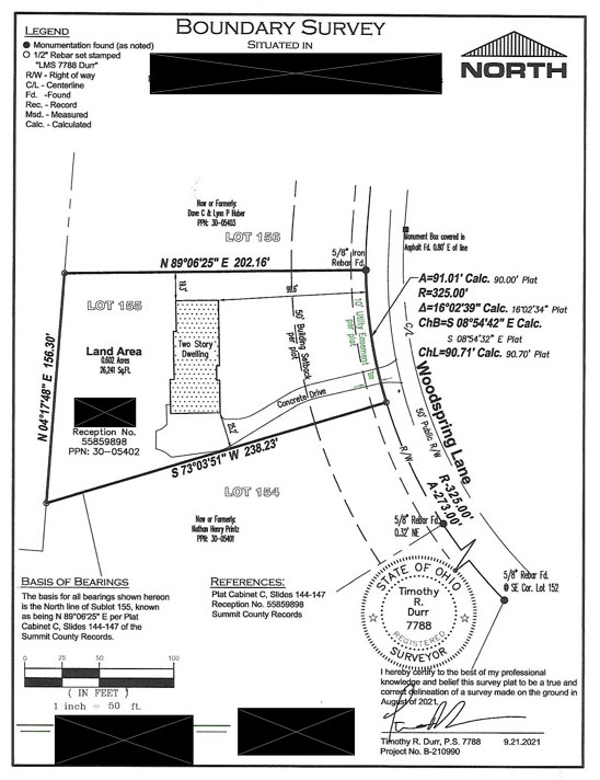
Property Line Survey
A survey is the most accurate type of map. Surveyors go to school to learn their trade. Obtaining licenses and certifications. Considered a legal document, a survey must hold up in court.
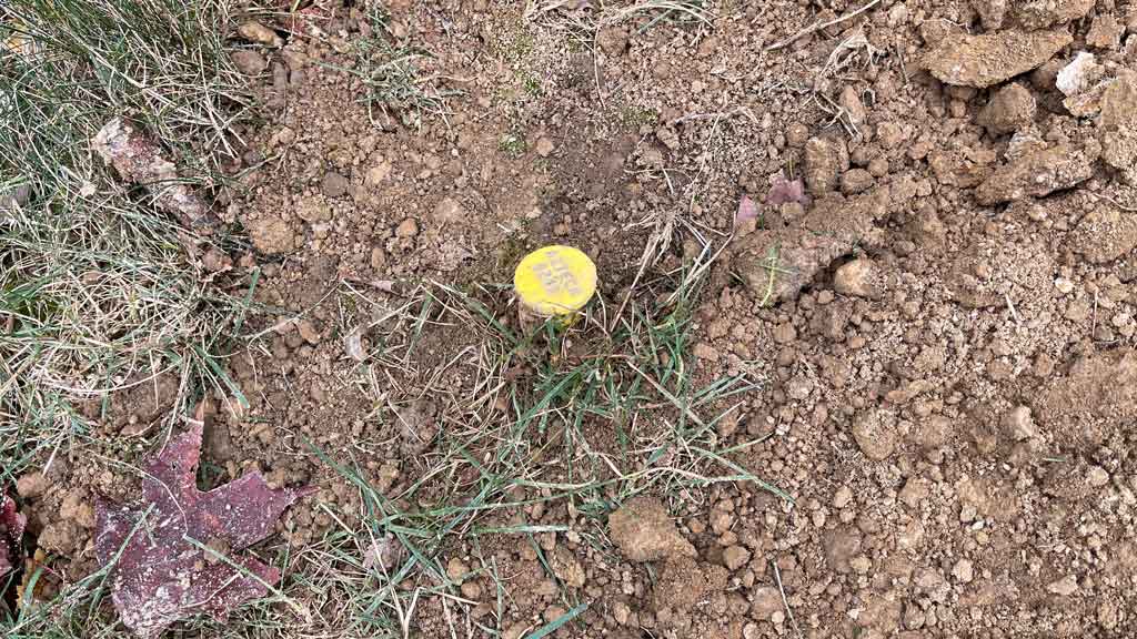
However, a survey is more than an accurate to scale drawing on a piece of paper. The surveyor marks the corners using metal stakes. Referred to as property pins.
Property pins are metal rebar stakes, driven into the ground. A yellow, red or orange cap sits on top of the stake. The cap contains the information of the surveyor that conducted to the survey. A pin survey is the most accurate way to establish property lines.
After setting the pins, the surveyor will also provide a map. It is a to scale drawing. The map shows all property dimensions. It also indicates if new pins were installed or existing pins were located. Most times it will also show the dwelling located on the property and it’s exact location in relation to the property lines.

GIS Property Lines

GIS stands for geographic information system. Almost every county has one. A quick google search will point you to yours. GIS websites allow the user to search for specific addresses.
They return results relating to property dimensions and total acrerage of the lot. While not as accurate as a pin survey, the dimension of each property line are accurate.
GIS sites provide aerial photographs of properties. Most will have the option to overlay the property lines on top of the aerial photograph. However, from my experience, they are sometimes deceiving.
A plane or satellite in space takes the pictures. As a result, property lines overlaid on photos don’t always line up in the correct location.
GIS maps are good to use as a reference. However, they are not accurate enough for establishing property lines for fence installation.
Google Earth Property Lines
Google earth is a site that allows a user to search specific locations and addresses. It has a measuring feature that is surprisingly accurate. However, just like GIS sites, it uses images taken from space.
Therefore, for establishing property lines, I do not recommend google earth. There is too much room for error.
Furthermore, while it does have excellent satellite images, it does not allow you to zoom in enough to measure to the nearest inch. I do recommend it for measuring the total footage of potential fence lines.
It does provide a close enough measurement for over the phone quotes from fence contractors. Or for homeowners figuring out fence material lists.
Mortgage Survey or Title Survey
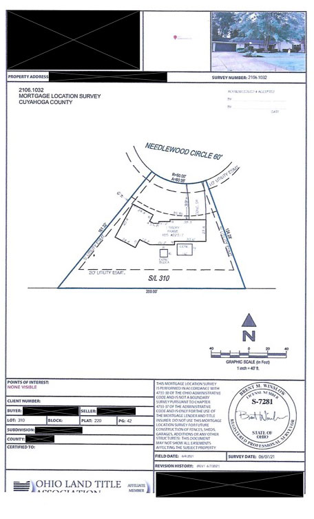
Mortgage surveys and title surveys are usually provided when purchasing a home. A drawing much like the one from an official pin survey is provided by the title company. There is a good chance you have one and may not know it.
Normally when you close on a house, the title or mortgage company will provide one. Usually buried in the stack of papers received when closing. If you don’t have one. A call to the title insurance company is worth a shot.
While a mortgage survey may look like a property line survey, it is not. More often than not, they state not for determining boundaries and only as a reference.
Furthermore, even though lot dimensions and many times house location are listed, there is no indication of existing or new pins.
Over my 26 year career, I have seen mortgage surveys with incorrect measurements. However, from my experience, they are pretty darn close. Close enough to file for permits and use for establishing lines.

Plot Maps and Plat Maps
Plot maps are maps of an individual lot. A plat map is a map showing how a piece of land is divided up into individual lots. The measurements are accurate and are public record.
However, just like the other type of maps, they do not necessarily mean there are property pins present. Furthermore, because they both pertain to the actual land only, they normally do not show the dwelling.
This makes it difficult to use for establishing fence lines. You may know your lot is 100′ x 300′. But if you don’t know where your house sits in relation to those lines, you won’t be able to accurately measure.
On the flip side, if you have one or two existing pins present, the measurements provided by plot maps and plat maps will come in handy. Allowing you to measure from existing pins to determine where the other property lines are.
Fence Layout and Property Lines
We’ve just learn about all of the types of property line maps. But how does fence layout relate to each one? Here is a quick summery. The fence placement in relation to property lines is determined by how accurate the property lines are established.
In layman’s terms, when you know where the property lines are, we can install the fence up to the permitted setback distance. As a result, allowing you to maximize the space inside of the fence.
This is crucial for fences that are installed up to or very close to the property line. However, not all cities, municipalities and or townships allow fences to go up to the property line anyway.
It is important to check with your local building or zoning department. See if if there are any setback requirements for fences. Many times there aren’t. Sometimes, it’s a foot, 3′ and I’ve even seen 5′ recommendations for setbacks.
A Pin Survey is the Best Option

If you already haven’t ran to this conclusion, having an official survey is the best option for establishing property lines. Yes it will cost more upfront. However, it is far cheaper than having an incorrectly installed fence line moved.
Furthermore, it will put any tension between neighbors to rest who may not agree on the exact location of the property lines.
That said, I’d say only 10% – 15% of my customers get surveys.
When Not to Get a Survey
There are many times when you don’t need a survey for establishing the layout of a fence. Here is a short list of 7 times that I would not recommend a survey.
- When you purchase a new house and the pins are existing and visible.
- When you purchase an older home and negotiate a pin survey into the closing costs.
- If you have 2 or more existing pins and access to any type of map showing accurate lot dimensions. In this case, some accurate measuring off of the existing pins should get you close enough.
- When you are certain you are well within your property lines with the fence location.
- If your neighbor is willing to sign an approval letter stating you both agree on the property line location. In many cities, when property pins cannot be located, this is required before a fence permit is issued.
- When you have access to a metal detector and can locate buried pins.
- When the fence is temporary and is removed after a short time or easily removed if required.
Who is Responsible for Fence Installed Over the Property Lines?
This is a tricky one. A question that is often disputed by both the contractor and homeowner in the rare event it happens. Here’s how we handle it from the perspective of an established fence company with over 32 years of business.
If we recommend a pin survey and you decline, the fence location is your responsibility. We will install the fence where you ask us to. However, we also have you sign a contract stating that we are not held liable if the fence is off the property.
If pins are exposed, the contractor should take full responsibility. You have done your part to establish the line. If they still get it wrong, it’s on them.
I bet you’re thinking for this to happen is almost impossible. However, I have seen it multiple times. Sometimes, it is an honest mistake by the installing crew. Sometimes, it is pure negligence. But it happens.
Conclusion
At the end of the day, if you aren’t sure where your property lines are located, the safe bet is to get a survey. I get it. Nobody wants to spend extra money. Fencing is expensive as it is.
But it will give you and your neighbors peace of mind. It will provide your contractor the confidence that they are installing the fence in the correct location.
Last. it will make the process of filing for and obtaining a fence permit much easier.

